Books, Music and More

Cruise with our
NEW Cruise Finder
Click Here
Home | Ports | Cruise Finder | Tour a Ship! | References | Books | About
|
|
|
In Association With Books, Music and More |
|
|
|
|
Find the PERFECT Cruise with our NEW Cruise Finder Click Here |
|
|
|
|
|
|
Home | Ports | Cruise Finder | Tour a Ship! | References | Books | About |
|||
|
Cruise Ports
Weather
|
Ketchikan,
Alaska, USA
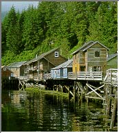
Ketchikan is the salmon capital of the world, and a paradise for fishermen and nature-lovers alike. The canneries bustle the year 'round, while the rustic boardwalk on Creek Street and the stilt-buildings in the harbor preserve a distinct pioneer feel. Nearby is Totem Bight, the world's largest collection of authentic totem poles. Contents | Description | Map | Explore | Excursions | History Ketchikan is located on the western coast of Revillagigedo Island, near the southernmost boundary of Alaska. It is 679 miles north of Seattle and 235 miles south of Juneau. The 2.2 million acre Misty Fjords National Monument lies 22 air miles east of Ketchikan. It is the first Alaska port of call for northbound cruise ships and State ferries. It lies at approximately 55° 20' N Latitude, 131° 38' W Longitude. The area encompasses 3 sq. miles of land and 1 sq. miles of water. The area lies in the maritime climate zone noted for its warm winters, cool summers, and heavy precipitation. Summer temperatures range from 51 to 65; winter temperatures range from 29 to 39. Ketchikan averages 162 inches (13.5 feet) of precipitation annually, including 32 inches of snowfall. Contents | Description | Map | Explore | Excursions | History
Contents | Description | Map | Explore | Excursions | History Southeast Alaska Visitors Center Contents | Description | Map | Explore | Excursions | History See quaint restaurants perched over water on stilts, browse through scores of fascinating shops and revel in spectacular views from every vantage point. Ketchikan's Indian name means "Thundering Wings of an Eagle." The name "Alaska's First City" has also been coined, as Ketchikan is frequently the first stop of the Inside Passage. You'll be fascinated by this town's rich Indian heritage, including the world's largest collection of magnificent totem poles. Canoe along secluded waters, take a floatplane to a remote mountain lake, or try your hand at sportfishing, with a personalbe local skipper at the helm. Join your fellow passengers on one of the following full-featured, guided shore excursions: Contents | Description | Map | Explore | Excursions | History Tongass and Cape Fox Tlingits have used Ketchikan Creek as a fish camp which they called "kitschk-hin," meaning creek of the "thundering wings of an eagle." The abundant fish and timber resources attracted non-Natives to Ketchikan. In 1885, Mike Martin bought 160 acres from Chief Kyan, which later became the township. The first cannery opened in 1886 near the mouth of Ketchikan Creek and four more were built by 1912. The Ketchikan Post Office was established in 1892. In the late 1890s, nearby gold and copper discoveries briefly brought activity to Ketchikan as a mining supply center. By 1936, seven canneries were in operation, producing 1.5 million cases of salmon. The need for lumber for new construction and packing boxes spawned the Ketchikan Spruce Mills in 1903, which operated for over 70 years. Spruce was in high demand during World War II, and Ketchikan became a supply center for area logging. A $55 million pulp mill was constructed at Ward Cove near Ketchikan in 1954. Its operation fueled the growth of the community. The mill's 50-year contract with the U.S. Forest service for timber was canceled, and the pulp mill closed in March 1997. Contents | Description | Map | Explore | Excursions | History |
|
|
| Disclaimer | Privacy Statement | Linking Guidelines | Webmaster |
|
By using this web site, you agree to the Terms of use. |
|
This site best viewed with
Internet Explorer and Netscape 5.0 or higher |