Books, Music and More

Cruise with our
NEW Cruise Finder
Click Here
Home | Ports | Cruise Finder | Tour a Ship! | References | Books | About
|
|
|
In Association With Books, Music and More |
|
|
|
|
Find the PERFECT Cruise with our NEW Cruise Finder Click Here |
|
|
|
|
|
|
Home | Ports | Cruise Finder | Tour a Ship! | References | Books | About |
|||
|
Cruise Ports
Weather
|
Panama Canal,
Panama
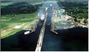
Spend an unforgettable day cruising the Panama Canal, a fifty-one mile waterway through the rainforest that is one of the world's engineering masterpieces. The ship glides down the canal with inches to spare, through locks that raise and lower it like a toy. Along the way it crosses enormous Gatun Lake, and the amazing Gaillard Cut, blasted out of a solid mountainside. Contents | Description | Map | Explore | Excursions | History The Panama Canal is 80 kilometers (50 miles) long from deep water in the Atlantic to deep water in the Pacific. It was cut through one of the narrowest and lowest saddles of the long, mountainous Isthmus that joins the North and South American continents. The original elevation was 95 meters (312 feet) above sea level where it crosses the Continental Divide in the rugged mountain range. The Canal runs from northwest to southeast with the Atlantic entrance being 54 kilometers (33.5 miles) north and 43.5 kilometers (27 miles) west of the Pacific entrance. The air distance between the two entrances is 69 kilometers (43 miles). It requires about 8 to 10 hours for an average ship to transit the Canal. During this brief time, the passengers aboard have an opportunity to see one of the modern wonders of the world in operation. The Canal's principal physical features are Gatun Lake a central man-made lake stretching nearly all the way across the Isthmus; Gaillard Cut, the 13 kilometers-long (8 1/2 miles) excavation through the Continental Divide that extends Gatun Lake to Pedro Miguel Locks; the locks on both sides of the Isthmus that raise ships between sea level and the lake (Gatun Locks on the Atlantic and Pedro Miguel and Miraflores Locks on the Pacific); and the ports of Balboa on the Pacific and Cristobal on the Atlantic. At the time the Canal was built, Gatun Dam was the largest earth dam that had ever been constructed, and Gatun Lake was the largest man-made lake in the world. The three sets of locks were the most massive concrete structures ever built. A ship that transits the Canal from the Atlantic to the Pacific enters the channel from Limon Bay at the Cristobal breakwater. This sea-level section of the Canal channel on the Atlantic side is 10.5 kilometers (6-1/2 miles) long and 152.4 meters (500 feet) wide and runs through a mangrove swamp that is only a few feet above sea level in most places. A ship is raised or lowered 26 meters (85 feet) in a continuous flight of three steps at Gatun Locks. Each lock chamber is 33.5 meters (110 feet) wide and 306 meters (1,000 feet) long. The length of Gatun Locks, including the two approach walls, is 1.9 kilometers (1-1/5 miles). Gatun Lake and DamGatun Lake, through which the ships travel for 37.6 kilometers (23-1/2 miles) from Gatun Locks to the north end of Gaillard Cut, covers an area of 418.25 square kilometers (163.38 square miles) and was formed by the construction of Gatun Dam across the Chagres River adjacent to Gatun Locks. The two wings of the dam and the spillway have an aggregate length of about 2.4 kilometers (1-1/2 miles). The dam is nearly a half mile wide at the base, tapering to a width of 30.5 meters (100 feet) at the crest, which is 32 meters (105 feet) above sea level, or 6.1 meters (20 feet) above the normal level of Gatun Lake. Gaillard CutBecause of its historical background, perhaps no part of the Canal trip is more interesting to the ship passenger than Gaillard Cut. During the Canal construction period it was called Culebra Cut, but was renamed for Col. David DuBose Gaillard, the engineer who was in charge of this section of the Canal work. The Gaillard Cut channel was originally a minimum 91.5 meters (300 feet) wide along its entire 12.6 kilometers (7.8 miles) length. In the 1930's, Canal authorities began a Cut Widening Project to increase channel width to a minimum 152 meters (498 feet) in some of the more slide prone areas. The objective was to have a catch-basin for slide debris in such areas. In the 1950's and 1960's the widening extended into other areas in order to improve navigation. By the early 1970's, the entire Gaillard Cut channel had a minimum width of 152 meters (498 feet). This permitted unrestricted two-way traffic for the vast majority of the ships using the Canal at the time. This portion of the channel is about 13.7 kilometers (8-1/2 miles) long and was carved through rock and shale for most of the distance. It was here that the principal excavation was required and here that devastating slides occurred during construction and soon after the Canal was opened. Coming from the Atlantic, a ship enters the Cut where the Chagres River flows into the Canal channel at Gamboa. In the Cut, the ships passes Gold Hill on the left, the highest promontory along the channel. It rises 202 meters (662 feet) above sea level. Contractor's Hill, seen on the west bank opposite Gold Hill, originally had an altitude of 125 meters (410 feet), but this was reduced to 113 meters (370 feet) to stabilize the hill in 1954. Another long-term program to further widen and straighten Gaillard Cut, begun in January of 1992, is designed to improve vessel scheduling and safety and to increase Canal transit capacity. A Pacific-bound ship enters Pedro Miguel Locks at the south end of Gaillard Cut. Here it is lowered 9.4 meters (31 feet) in one step to Miraflores Lake, a small artificial body of water 1.6 kilometers (1 mile) wide that separates the two sets of Pacific locks. The length of Pedro Miguel Locks is 0.27 kilometers (5/6 of a mile). A transiting ship is lowered the remaining two steps to sea level at Miraflores Locks, which is slightly over 1.6 kilometers (1 mile) in length. The lock gates at Miraflores are the tallest of any in the system because of the extreme tidal variation in the Pacific Ocean. Source: Panama Canal Commision. Contents | Description | Map | Explore | Excursions | History
Contents | Description | Map | Explore | Excursions | History Cristobol Contents | Description | Map | Explore | Excursions | History There are no shore excursions during a transit of the Panama Canal, currently, since there are no passenger port facilities. A port is currently planned, and when it is completed it will enable ships to add shore excursions at the Panama Canal to their itineraries. Until then, most ships narrate the entire transit, providing excellent descriptions of the canal, its flora, fauna, and history. Contents | Description | Map | Explore | Excursions | History Among the great peaceful endeavors of mankind that have contributed significantly to progress in the world, the construction of the Canal stands as an awe-inspiring achievement. The unparalled engineering triumph was made possible by an international work force under the leadership of American visionaries, who made the centuries-old dream of uniting the two great oceans a reality. In 1534, Charles I of Spain ordered the first survey of a proposed canal route through the Isthmus of Panama. More than three centuries passed before the first construction was started. The French labored 20 years, beginning in 1880, but disease and financial problems defeated them. In 1903, Panama and the United States signed a treaty by which the United States undertook to construct an interoceanic ship canal across the Isthmus of Panama. The following year, the United States purchased from the French Canal Company its rights and properties for $40 million and began construction. The monumental project was completed in ten years at a cost of about $387 million. Since 1903 the United States has invested about $3 billion in the Canal enterprise, approximately two-thirds of which has been recovered. The building of the Panama Canal involved three main problems—engineering, sanitation, and organization. Its successful completion was due principally to the engineering and administrative skills of such men as John F. Stevens and Col. George W. Goethals, and to the solution of extensive health problems by Col. William C. Gorgas. The engineering problems involved digging through the Continental Divide; constructing the largest earth dam ever built up to that time; designing and building the most massive canal locks ever envisioned; constructing the largest gates ever swung; and solving environmental problems of enormous proportions. Now, more than 80 years after the first official ocean-to-ocean transit of the waterway, the United States and Panama have embarked on a partnership for the management, operation and defense of the Panama Canal. Under two new treaties signed in a ceremony at OAS headquarters in Washington, D.C., on September 7, 1977, the Canal will be operated until the turn of the century under arrangements designed to strengthen the bonds of friendship and cooperation between the two countries. The treaties were approved by Panama in a plebiscite on October 23, 1977, and the U.S. Senate gave its advice and consent to their ratificaton in March and April 1978. The new treaties went into effect October 1, 1979. Source: Panama Canal Commision. Contents | Description | Map | Explore | Excursions | History |
|
|
| Disclaimer | Privacy Statement | Linking Guidelines | Webmaster |
|
By using this web site, you agree to the Terms of use. |
|
This site best viewed with
Internet Explorer and Netscape 5.0 or higher |