Books, Music and More

Cruise with our
NEW Cruise Finder
Click Here
Home | Ports | Cruise Finder | Tour a Ship! | References | Books | About
|
|
|
In Association With Books, Music and More |
|
|
|
|
Find the PERFECT Cruise with our NEW Cruise Finder Click Here |
|
|
|
|
|
|
Home | Ports | Cruise Finder | Tour a Ship! | References | Books | About |
|||
|
Cruise Ports
Weather
|
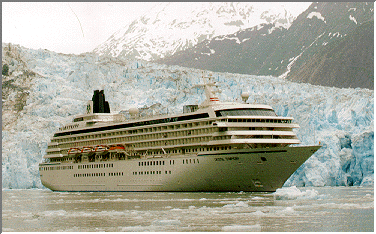
Glacier Bay,
Alaska, USA
This stunning amphitheater of glaciers and granite peaks is best viewed from the sea. The ice in Glacier Bay fell as snow centuries ago, on the mountains that ring the bay. Compressed by its own tremendous weight it flows seaward, producing some of the fastest-moving glaciers known. In the summer, rare Humpback whales come here to feed—with luck you'll see one of these gentle giants. Contents | Description | Map | Explore | Excursions | History Glacier Bay National Park and Preserve (GLBA) is in the panhandle of southeast Alaska. The center of the park is approximately 90 miles northwest of Juneau and approximately 600 miles southeast of Anchorage. The primary features that define the perimeter of this unit are the Gulf of Alaska to the west, the Chilkat Mountain Range to the east, Cross Sound and Icy Strait to the south, and the St. Elias Mountains and Alsek River to the north. Glacier Bay National Monument was established in 1925 by presidential proclamation in order to protect "a number of tidewater glaciers ... in a magnificent setting of lofty peaks ...; a great variety of forest covering consisting of mature areas, bodies of youthful trees which have become established since the retreat of the ice which should be preserved in absolutely natural condition, and great stretches now bare that will become forested in the course of the next century; a unique opportunity for the scientific study of glacial behavior and of resulting movements and developments of flora and fauna and of certain valuable relics of interglacial forests; historic interest, having been visited by explorers and scientists since the early voyages of Vancouver in 1794 who left valuable records of such visits and explorations." Another proclamation added additional land to the monument in 1939. The Alaska National Interest Lands Conservation Act of 1980 changed the designation to national park and added a preserve to the unit. Source: National Park Service, Ken Shoenberg. Contents | Description | Map | Explore | Excursions | History
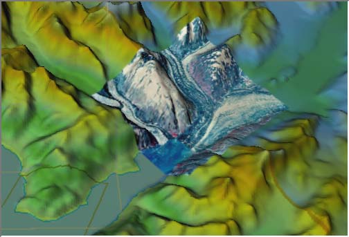
Topographic Map | Aerial Photo | Alaska3D Note: This image was rendered with TruFlite 3D Terrain Visualization software, a very nifty $295 software package. It used USGS Digital Elevation Model (DEM) data, TIGER MAP data, and a USGS EROS Aerial Photograph of the confluence of Grand Pacific (far right) and Marjorie (far left) Glaciers at the north end of Glacier Bay. Cruise on the Web is currently experimenting with various techniques for providing unique 3D maps of Alaska. If you would like more information about this image, please e-mail: info@cruiseontheweb.com or, if you would like more information on the rendering software, visit the TruFlite web page. Contents | Description | Map | Explore | Excursions | History Glaciers Contents | Description | Map | Explore | Excursions | History There are no shore excursions while visiting Glacier Bay National Park. However, the park rangers who board the ship when it first enters the bay narrate major highlights of this inspirational day. Contents | Description | Map | Explore | Excursions | History The Russian discovery of sea otters in 1741 led to the Russian expansion into this region. In 1786, the French explorer La Perouse,arrived at Lituya Bay in two ships and contacts were made with the local Tlingits during his 26-day stay. In 1788 a Russian galleon made a brief stop in Lituya Bay and claimed it for the Russian Empire. In 1794, Vancouver explored this coast, including Glacier Bay, which at that time was still choked with ice. Commercial activities increased over the next decades, including the establishment of Hudson's Bay and trading stations along the coast. With the acquisition of Russian-America by the United States in 1867, further development took place. The discovery of gold brought an influx of miners. In August 1890, a group of miners met on Willoughby Island in glacier Bay and organized the Berry mining district. Other developments included a saltery at Bartlett Cove in the late 1890s, several fox farms and the Dundas Bay cannery, started in 1890 and abandoned in 1935. These and other such developments have left us the opportunity for historical archeological work and preservation. John Muir made his first visit in 1879 and as a result of these explorations and the subsequent publicity, the monument was established in 1925. As a matter of fact, the first tourist ship entered the harbor in 1893, as gradually, Bartlett Cove became a stopping and supply point for the tourist trade, as it is today. Source: National Park Service, Ken Shoenberg. Contents | Description | Map | Explore | Excursions | History |
|
|
| Disclaimer | Privacy Statement | Linking Guidelines | Webmaster |
|
By using this web site, you agree to the Terms of use. |
|
This site best viewed with
Internet Explorer and Netscape 5.0 or higher |